Оценка AgriTech.tr
Редакционная структура и рекомендации по сравнению, подготовленные для формулирования требований.
 AgriTech.trТехнологии
Технологии
Технические руководства по выбору и спецификации для подбора сельскохозяйственной продукции и оборудования.
Satellite crop intelligence and agricultural data software
A satellite-based agricultural intelligence platform with NDVI, NDRE and other vegetation indices, field and multi-parcel dashboards, weather and climate-risk alerts, AI-assisted agronomic workflows, data APIs, historical analysis, and integration options.
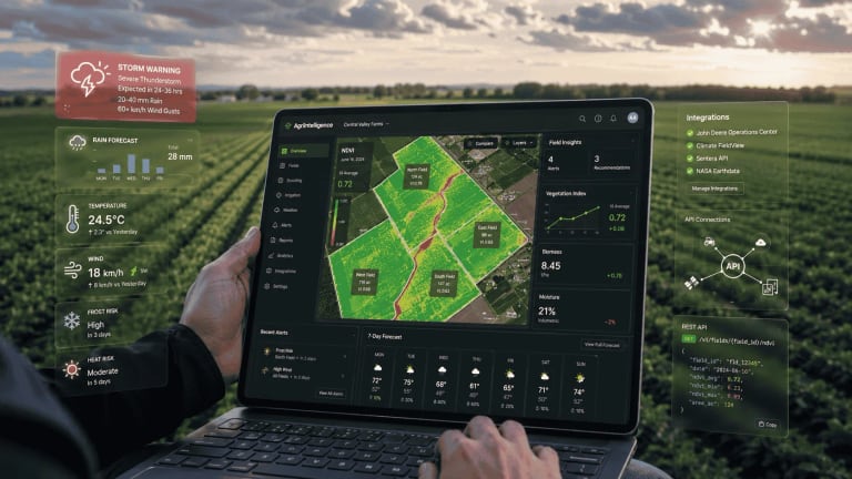 Иллюстративное изображение
Происхождение поставки
Турция
Объём закупки
Спецификация для подбора
Последняя проверка
13 июл. 2026 г.
Редакционная структура и рекомендации по сравнению, подготовленные для формулирования требований.
Ориентировочные диапазоны для планирования, а не гарантированная окончательная комплектация.
Публичные материалы подтверждают технический контекст; актуальные коммерческие сведения всё ещё требуют подтверждения.
Satellite crop intelligence and agricultural data software
Технические параметры, используемые для формулирования требований и сравнения комплектаций, подтверждённых поставщиками.
Satellite crop, weather, climate-risk, agronomic decision-support, B2B portfolio, data-delivery, and API platform
Multi-index crop monitoring, weather intelligence, field-risk alerts, advisory workflows, enterprise SaaS, scheduled data delivery, and agricultural APIs
Farm and portfolio intelligence for crop production, supply-chain resilience, climate-risk management, ESG, carbon, finance, and parametric-trigger workflows
More than 11 configurable layers can include NDVI, NDRE, SAVI, NDMI, NDWI, NDTI, terrain, residue, and other project-specific indices
Sentinel-class imagery around 10 m and commercial high-resolution imagery around 3 m, with source entitlement, native GSD, delivered resolution, cloud handling, and revisit cadence defined in the project
Технические параметры, используемые для формулирования требований и сравнения комплектаций, подтверждённых поставщиками.
Практические сведения, помогающие сравнивать варианты.
Satellite crop monitoring for farms and agronomy teams using NDVI, NDRE, SAVI, NDMI, NDWI, NDTI, or other vegetation and field-condition layers to identify within-field variability, prioritize scouting, and compare change through the season.
Cloud-aware image-review and field-anomaly workflows where image date, sensor source, field geometry, parcel statistics, spatial zones, and processing provenance must be reviewed before agronomic action.
Weather and climate intelligence workflows combining forecast context, meteorological data, severe-weather messages, storm or hail tracking, and field-specific risk notifications.
Agronomic advisory and scouting workflows where disease probabilities, AI-generated guidance, spraying-time context, or personalized recommendations trigger field verification rather than replacing agronomist inspection.
Cooperative, dealer, advisory, and contract-production portfolio monitoring where teams supervise large numbers of parcels, compare agricultural, climatic, and sensor data, generate reports, maintain field histories, and rank inspection priorities.
Agricultural insurance and finance workflows requiring parcel, regional, historical climate, satellite, drought, storm, flood, or other risk context, subject to independent validation, reproducibility, governance, and human-review requirements for the intended decision.
Agribusiness and food-chain data integration where satellite, weather, climate, field, and alert information must feed an ERP, sourcing dashboard, internal advisory tool, ESG workflow, supplier portal, or risk process through APIs or enterprise data delivery.
Developer and data-engineering workflows evaluating agricultural and climate APIs for station data, satellite imagery, index outputs, weather, drought, accumulations, spraying suitability, frost/chilling, alerts, reports, or other services after current endpoint and entitlement confirmation.
Climate-risk and parametric-insurance workflows evaluating data-driven trigger context, source hierarchy, event detection, basis risk, reproducibility, and audit requirements.
Carbon-farming and ESG teams evaluating remote-sensing, field-history, residue/tillage, and climate-data inputs for MRV-related workflows, with methodology, measurement-versus-model boundaries, uncertainty, export, and programme alignment checked separately.
Plan comparison for farmers deciding between free NDVI/weather access and higher-tier advanced indices, terrain layers, AI advisory, messaging channel assistance, storm/hail tracking, climate-station, or corporate API capabilities.
Личность поставщика, происхождение, доступность, окончательная комплектация, сертификаты, цена, срок поставки, гарантия, доставка и договорные условия требуют актуального подтверждения.
Методы, источники и контекст, использованные при подготовке этой страницы исследования.
This profile defines a sourcing requirement for satellite crop and weather-risk intelligence platform. Suitable suppliers, origin, availability, and commercial terms are confirmed for the buyer’s project. The sourcing brief is structured around capacity, application, operating environment, required standards, destination, and delivery scope; the exact configuration requires supplier confirmation.
For farms, cooperatives, agronomy teams, contract-production businesses, insurers, banks, food companies, and software teams comparing satellite crop monitoring software in Türkiye, successful deployment depends on whether field boundaries can be onboarded reliably, which satellite sources and spectral indices are actually available, how clouds and image dates are handled, how weather and climate signals are converted into field alerts, how agronomic recommendations are governed, and whether data can move into an ERP, GIS, underwriting model, ESG workflow, or another agricultural application.
This configurable agricultural intelligence platform combines AI, satellite imagery, climate data, field-specific notifications, web and mobile access, multi-parcel B2B tools, data delivery, and APIs. Configurable analytics include NDVI, NDRE, SAVI, NDMI, NDWI, NDTI, residue indicators, weather forecasts, meteorological data, spraying-time guidance, elevation and slope mapping, storm and hail tracking, AI-assisted agronomic advice, and messaging workflows.
The platform is configured as an agricultural intelligence and climate-data stack combining satellite monitoring, field-risk analytics, agricultural weather, B2B portfolio software, APIs, and governed data delivery. Banking, insurance, ESG, carbon, procurement, and supply-chain workflows are scoped as project modules with their own data rights, validation, decision controls, and acceptance criteria.
| Technical layer | Technical capability | Project specification |
|---|---|---|
| Satellite crop monitoring | Multi-index crop monitoring with NDVI, NDRE, SAVI, NDMI, NDWI, NDTI, and project-specific residue or soil-cover layers. | Exact formula, spectral bands, imagery source, native and delivered resolution, cloud mask, acquisition date, compositing, scaling, valid range, no-data treatment, and archive depth. |
| Field intelligence | Field-level anomaly detection and comparison of satellite, weather, agronomic, and sensor data. | Boundary import, minimum polygon size, geometry validation, coordinate system, edge-pixel treatment, parcel statistics, thresholds, and traceability to image and processing version. |
| Weather and climate | Configurable 7-, 10-, or 15-day forecast horizons combined with observations and historical climate data. | Forecast model, issue frequency, grid size, lead time, archive, station or sensor assimilation, elevation, bias correction, missing data, and grid-versus-field interpretation. |
| Risk notifications | Field-specific disease, frost, drought, storm, hail, lightning, precipitation, and severe-weather alerts. | Crop and disease coverage, thresholds, inputs, latency, validation region, false-alert handling, channels, escalation, and field-observation closure. |
| Agronomic decision support | Spraying-window analysis, agronomic advisory workflows, conversational assistance, and personalized field recommendations. | Rule, statistical, machine-learning, or generative method; supported crops and languages; provenance, explanation, confidence, safety limits, model version, and audit trail. |
| Terrain context | DEM-derived elevation and slope layers for drainage, erosion, access, and field-operation planning. | DEM source, horizontal resolution, vertical datum, resampling, slope algorithm, unit, edge handling, and fitness for the intended decision. |
| B2B SaaS | Multi-organization monitoring of thousands of parcels, portfolio comparison, reporting, and historical archives. | Organization hierarchy, roles, field ownership, bulk onboarding, offboarding, audit logs, tenant separation, retention, training, and support. |
| Agricultural data API | APIs for field geometry, imagery, indices, weather, risk, alerts, ERP feeds, ESG, and enterprise analytics. | Base URL, endpoint catalogue, OpenAPI, versioning, authentication, quotas, asynchronous jobs, retries, webhooks, SDKs, SLA, and migration policy. |
| Data purchase and enterprise delivery | SaaS access, API integration, or scheduled bulk-data delivery. | Format, geography, period, refresh, source and derived-data rights, redistribution, retention, deletion, and processing terms. |
| Climate-risk and insurance context | Governed climate-risk analytics and parametric-trigger support for agricultural portfolios. | Trigger definition, source hierarchy, basis risk, reproducibility, outages, disputes, insurer responsibility, and the boundary between analytics and insurance delivery. |
Satellite indices are best treated as screening, comparison, and prioritization layers. They can help a user decide where to inspect first, compare spatial patterns, and follow change over time. They do not, by themselves, establish the biological, chemical, hydraulic, or operational cause of every anomaly.
The formulas below describe common remote-sensing conventions for technical comparison. The contracted technical schedule defines the exact bands, constants, processing chain, scaling, cloud handling, sensor-specific treatment, output range, and version used for every operational layer.
| Named layer | Common technical interpretation | Formula or implementation question |
|---|---|---|
| NDVI | Red and near-infrared vegetation index commonly used as a proxy for vegetation greenness and canopy activity. | Common form: (NIR - Red) / (NIR + Red). Confirm source bands, surface-reflectance product, scaling, cloud mask, and cross-sensor harmonization. Dense canopy can reduce sensitivity and soil background can affect low-cover fields. |
| NDRE | Red-edge and near-infrared index often used to examine canopy or chlorophyll-related variation, including later crop stages. | Common form: (NIR - RedEdge) / (NIR + RedEdge). Confirm which red-edge band is selected and whether values from different sensors are normalized before comparison. |
| SAVI | Soil-adjusted vegetation index intended to reduce some soil-background influence in lower-cover conditions. | Common form: ((NIR - Red) / (NIR + Red + L)) × (1 + L). Request the L value and whether a standard or modified implementation is used. |
| NDMI | Near-infrared and short-wave infrared index commonly used for vegetation or canopy moisture context. | A common form is (NIR - SWIR) / (NIR + SWIR). It is not a direct volumetric soil-moisture sensor reading; crop stage, canopy, exposed soil, and atmosphere can affect interpretation. |
| NDWI | A label used for more than one normalized-difference water-related formulation in remote sensing. | Ask for the exact bands and intended interpretation. Some workflows use Green/NIR for surface-water context; others use NIR/SWIR for vegetation-water context and may overlap conceptually with NDMI naming. |
| NDTI | Normalized-difference tillage-related index used in residue or tillage remote-sensing workflows. | Request the exact SWIR bands, formula, calibration, residue assumptions, crop and soil conditions, and validated operational use case. |
| Residue or soil-cover index | A project-specific spectral layer for residue, tillage, or soil-cover interpretation. | Define the exact SWIR or other bands, formula, calibration data, output range, crop and soil assumptions, validation method, and intended operational decision. |
A buyer should also ask whether a displayed parcel value is the mean, median, percentile, weighted statistic, minimum/maximum, or another aggregation. A single parcel average can hide a small stress zone; a high-resolution raster can also show numerical variability that is not agronomically meaningful. For repeat monitoring, the record should preserve image date, time where available, sensor or source, cloud score, pixel size, processing version, index formula version, and the exact field geometry used.
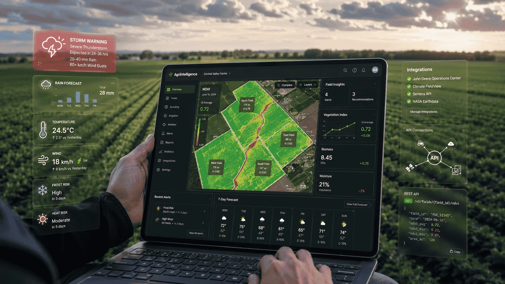
Digital crop-scouting workflow. Photo by Mark Stebnicki via Pexels. Image source · Pexels License.
The imagery pipeline can combine Sentinel-class 10 m data with commercial high-resolution imagery around 3 m where field size or scouting precision requires it. Cloud-coverage filters, acquisition metadata, asynchronous premium-image ordering, job-status polling, and retry behavior are defined in the integration scope.
The contracted API package defines authentication, user and account operations, field geometry, imagery entitlements, index products, meteorological-station data, alerts, reporting, versioning, and OpenAPI specifications. The endpoint and entitlement matrix is attached to the project scope so every production integration uses a controlled API version.
Production integration is designed from the contracted endpoint matrix and OpenAPI specification supplied with the selected data products.
For satellite procurement and validation, ask:
A useful crop-monitoring workflow is not simply “open NDVI and look for red areas.” A defensible operational process usually includes:
Field geometry → image eligibility → processing metadata → index or derived layer → within-field comparison → anomaly ranking → scouting → observation → action → outcome.
For each step, a buyer should decide what must be recorded.
The platform should preserve the polygon version used for an analysis. If a field boundary changes during the season, historical values may no longer be directly comparable unless the old geometry is retained.
The user should be able to see why an image is included or excluded. “Cloud coverage 10%” at scene level is not enough when the 10% cloud happens to cover the entire field.
Compare both the parcel-level statistic and the spatial distribution. A 0.62 field average can represent a uniform field or a field split between strong and weak zones.
A change between two dates can result from crop growth, harvest, irrigation, cloud contamination, different solar conditions, sensor differences, or processing changes. Time-series analytics should preserve provenance.
The software should help the agronomy team reach the right location. Useful operational fields include map coordinates, navigation link, anomaly severity, first-seen date, last-seen date, and a way to attach a scouting result.
A platform becomes more valuable when the organization can connect the signal to the field outcome: confirmed nutrient issue, irrigation fault, disease symptom, weed pressure, lodging, harvest, no issue found, or another classified result.
For large portfolios, AgriTech.tr recommends asking whether anomaly ranking can be tuned by crop, growth stage, field size, commercial importance, contract status, and persistence across multiple images.
Forecast horizons can be configured for 7, 10, or 15 days, with field-specific risk notifications, disease-probability alerts, severe-weather messages, and optional storm and hail tracking.
Extended data modules can cover weather, drought, long-term risk, accumulations, spraying suitability, frost, chilling, lightning, storm polygons, radar-derived events, alert delivery, and reporting workflows.
Relevant technical data products include:
apikey in a request header and that keys may have daily, monthly, or yearly limits and may not enable every API product.The project endpoint catalogue identifies the supported response schema, satellite entitlement, notification channel, quota, retention period, and service level for every selected data product.
For agronomic decisions, a buyer should distinguish at least four layers:
These data can all be useful, but they are not interchangeable.
For frost, spraying, disease-risk, irrigation, and insurance workflows, ask:
A 2 km, 5 km, or 12 km gridded output may still be useful for portfolio-level screening. It should not automatically be treated as equivalent to an instrument installed in the target field.
Spraying-suitability analysis combines humidity, precipitation, wind speed, temperature, leaf-wetness or disease context, forecast uncertainty, chemical label constraints, and local operating rules. The project defines suitable, unsuitable, and prohibited windows together with update frequency, alert lead time, station or grid source, and human approval.
For a farm or contract-production organization, this feature should be evaluated against the actual pesticide application workflow. Ask for:
A generic “suitable for spraying” message should not replace the pesticide label, local regulation, agronomist judgment, or the operator’s assessment of actual field conditions.
Customized notifications can combine disease-probability signals with AI-assisted agricultural guidance and field-scouting workflows.
For technical evaluation, a disease-risk alert should be treated as a decision-support signal and scouting trigger, not as a laboratory diagnosis. Ask for:
For cooperatives and advisory teams, the most useful workflow may be:
alert → portfolio ranking → field assignment → scout visit → observation → agronomic decision → action → outcome record
The platform should then be evaluated by time-to-detection, scouting hours, verified-alert rate, missed-event review, field response time, and completeness of the decision record rather than by the number of alerts generated.
Agronomic decision support can combine spraying-window analysis, a structured advisory workflow, conversational assistance, and personalized field recommendations. The contracted scope defines whether each output is rule-based, statistical, machine-learning based, retrieval-assisted, generative, or agronomist-authored; it also defines supported crops and languages, explanation, confidence, source traceability, model version, contraindications, escalation, and audit history.
Ask:
AgriTech.tr recommends that enterprise buyers test the assistant with known agronomic scenarios, ambiguous questions, contradictory field data, unsupported crops, and safety-sensitive pesticide questions before rollout.
The B2B configuration provides a single agricultural-management layer for monitoring thousands of parcels, comparing fields and orchards with agricultural, climate, satellite, and sensor data, generating reports, and retaining historical archives.
Enterprise use cases include:
The project separates SaaS, data, and API delivery because each model has different operational and commercial requirements. A dashboard subscription, a dataset licence, and an API integration have different requirements for ownership, data portability, auditability, support, and continuity.
| Enterprise requirement | Questions to put into the RFP or pilot |
|---|---|
| Field onboarding | GeoJSON, KML, SHP, WKT, cadastral reference, CSV coordinates, API creation, bulk upload limits, coordinate systems, polygon validation, duplicate handling, geometry history, and error reports. |
| Organization model | Parent/child accounts, dealer/customer hierarchy, cooperative membership, contract grower, region, crop, advisor, field ownership, reassignment, and offboarding. |
| Identity and security | JWT or API-key model, SSO/SAML/OIDC, MFA, password policy, IP restrictions, service accounts, secret rotation, role model, admin privileges, audit log, and tenant separation. |
| API operations | Current base URL, OpenAPI spec, pagination, rate limits, quotas, idempotency, asynchronous jobs, retries, backoff, error taxonomy, sandbox, SDKs, versioning, and deprecation notice. |
| Alerts and events | App, SMS, email, messaging channel, webhook or POST support; signatures/authentication; retry policy; delivery logs; deduplication; acknowledgement; escalation; sleeping windows; and all-clear events. |
| Data portability | Raw data access, derived-data export, field history, image metadata, index values, alert history, advisory history, map rasters, vector zones, CSV/JSON/XLSX, and bulk account-closure export. |
| Data governance | Controller/processor roles, field-boundary ownership, source-data rights, derived-data rights, retention, deletion, backups, subprocessors, hosting region, cross-border transfer, and training use. |
| Service management | SLA, uptime calculation, support hours, severity definitions, response and resolution targets, maintenance windows, incident communication, disaster recovery, RPO, and RTO. |
| Model governance | Model identifier, input provenance, validation report, calibration, change notification, confidence/severity scale, human review, explainability, rollback, and archived historical outputs. |
| Commercial continuity | Plan changes, premium imagery, SMS or message cost, API overage, station or sensor cost, custom integration, data exit, contract termination, and transition support. |
Enterprise integrations are assembled from controlled API modules rather than an undocumented collection of endpoints. The project can include:
The entitlement matrix records the base URL, API version, OpenAPI document, enabled products, satellite sources, native and delivered resolution, quotas, rate limits, synchronous or asynchronous behavior, webhook security, retention, SLA, deprecation policy, and commercial overage rules.
Satellite and climate intelligence can support banking, insurance, ESG, carbon, sourcing, and portfolio-risk workflows. These uses require stronger source lineage, reproducibility, model governance, human review, challenge procedures, and audit exports than a farmer-facing scouting map.
For credit, insurance, or ESG use, ask:
A parcel-level risk score is not automatically credit-decision-grade, insurance-grade, or regulatory-grade merely because it is generated from satellite and climate data.
Carbon-farming projects can use the platform as a data and workflow layer for Measurement, Reporting, and Verification (MRV). The project separates direct measurements, farm-activity records, remote-sensing observations, modelled outputs, uncertainty, audit evidence, methodology alignment, permanence or reversal controls, and independent verification responsibilities.
For an MRV project, buyers should separate:
Ask which methodology or carbon programme the workflow supports, which variables are measured versus modelled, how uncertainty is calculated, how reversals and permanence are handled where relevant, how field boundaries and historical land use are documented, and what export is produced for an independent verifier.
The presence of NDVI, NDTI, residue index, climate data, or field histories does not by itself establish compliance with a specific carbon standard.
Best suited to users who want a combined view of field boundaries, satellite crop-health context, weather, spraying windows, and alerts. The key test is whether the platform reduces the time between seeing a risk signal and inspecting the correct part of the field.
Useful where one team supervises many farms and needs a ranked scouting queue. Compare multi-user permissions, portfolio filters, alert triage, field assignments, field notes, history, image metadata, and the ability to move from a regional overview to parcel-level evidence.
B2B monitoring is suitable for large parcel portfolios and contract-production operations. Buyers should test supplier and field onboarding, regional comparison, exception reporting, crop-stage context, data export, and integration with procurement, ERP, or supplier master data.
Insurance and finance configurations can combine climate history, forecasts, satellite observations, and field-level risk context. These organizations should distinguish decision-support features from audit-grade or automated-decision evidence and independently validate model governance, lineage, geospatial precision, reproducibility, and challenge processes.
Relevant where an organization wants agricultural or climate data inside its own application, ERP, ESG report, underwriting process, advisory tool, or risk engine. API versioning, entitlements, data rights, quotas, asynchronous jobs, webhooks, bulk delivery, and service terms are more important than the farmer-app feature list.
Parametric-insurance projects can use the platform as a governed data and trigger-analysis layer. These teams should focus on trigger source, index definition, basis risk, observation hierarchy, data outage rules, trigger reproducibility, audit trail, payout responsibility, and the contractual boundary between data service and insurer.
Relevant for organizations evaluating remote-sensing and climate-data inputs for MRV or sustainability workflows. The methodology, uncertainty treatment, data lineage, measurement-versus-model boundary, programme alignment, and independent verification path should be checked separately.
The commercial package is sized by monitored area, number of fields and users, imagery source, forecast horizon, API volume, notification traffic, data retention, integration work, and support level—not by a predefined package name.
| Capability group | Configurable project scope | Commercial definition |
|---|---|---|
| Core field monitoring | Field boundaries, NDVI, meteorological data, map history, and 7-day weather context. | Fields, hectares, users, revisit cadence, archive depth, and report frequency. |
| Expanded crop intelligence | NDRE, SAVI, NDMI, NDWI, terrain layers, 10-day forecasts, alerts, scouting queues, and agronomic workflows. | Supported crops, analytics, notification channels, training, and validation scope. |
| Advanced risk package | 15-day forecasts, storm and hail tracking, drought, frost, spraying suitability, premium imagery, and sensor or station integration. | Data entitlements, station hardware, message volume, premium-image orders, and support SLA. |
| Enterprise data and API | Multi-organization B2B dashboard, API library, bulk onboarding, data delivery, SSO, audit logs, custom integration, and governed export. | API calls, quotas, service accounts, data rights, custom work, uptime, response targets, and exit assistance. |
The quotation also defines premium imagery, SMS or messaging costs, data-export rights, custom integrations, onboarding, training, support hours, SLA, backups, and retention after contract completion.
A practical evaluation should use real fields and a pre-agreed scoring method.
Do not use a generic claim such as “AI increased yield” as the acceptance metric. Define operational measures such as:
A satellite vegetation index is not by itself a crop-disease diagnosis. A weather grid is not automatically equivalent to an on-field weather station. Disease probability, spraying suitability, AI advice, parcel risk scores, carbon indicators, and insurance triggers become operationally useful only when their source, model version, resolution, uncertainty, and field-validation procedure are defined.
The project acceptance plan therefore includes:
Acceptance criteria are tied to the actual operational decision: scouting priority, irrigation review, spraying window, contract-production monitoring, portfolio reporting, risk analysis, or API integration.
The sourcing brief can be used to define the application, technical interfaces, documentation, and service requirements before supplier research begins.
For project configuration, technical quotation, RFP criteria, pilot design, API evaluation, field-validation protocols, or identifying alternative Turkish AgriTech solutions, contact info@agritech.tr.
The cover and crop-scouting photographs provide field-monitoring context and are used under the Pexels License. Photographer and source credits are retained in the reference section.
AgriTech.tr can structure the technical requirement and compare current supplier responses for the buyer’s project. Installation, commissioning, operator training, warranty, spare-parts, and after-sales scope must be confirmed in each supplier quotation. The final scope should be documented against the approved application, capacity, site conditions, destination, and delivery schedule in the selected supplier quotation and contract.
Методы, источники и контекст, использованные при подготовке этой страницы исследования.
Technical reference used for system specification, project engineering, and procurement planning.
Technical reference used for system specification, project engineering, and procurement planning.
Technical reference used for system specification, project engineering, and procurement planning.
Technical reference used for system specification, project engineering, and procurement planning.
Technical reference used for system specification, project engineering, and procurement planning.
Индикаторы показывают, откуда получена публичная информация и что ещё требует подтверждения. Они не являются знаками аккредитации поставщика.
Оценка AgriTech.tr
Редакционная структура и рекомендации по сравнению, подготовленные для формулирования требований.
Типовые инженерные диапазоны
Ориентировочные диапазоны для планирования, а не гарантированная окончательная комплектация.
5 публичных источников
Публичные материалы подтверждают технический контекст; актуальные коммерческие сведения всё ещё требуют подтверждения.
Заявления поставщика
В этом профиле доказательств заявления поставщика не представлены.
Сведения, подтверждённые документами
К этой карточке не прикреплена исходная запись о проверке.
Изображения карточки
Изображения носят иллюстративный характер и могут не отражать окончательную комплектацию поставки.