Independent guide
AgriTech.tr prepared this explanation and comparison guidance.
 AgriTech.trTechnologies
Technologies
Practical guides for understanding and comparing agricultural products and equipment.
Remote sensing and crop intelligence platform
Satellite and drone imagery are combined with crop-health, water-stress and nitrogen-status analytics, weather intelligence, field records, crop classification, and configurable reporting for multi-field agricultural operations.
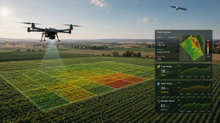 Illustrative image
Supplier location
Türkiye
Guide type
Buying guide
Last reviewed
13 Jul 2026
AgriTech.tr prepared this explanation and comparison guidance.
Useful starting points, not a guaranteed final configuration.
Public sources support the technical overview. Current prices, availability, and commercial details still need confirmation.
Remote sensing and crop intelligence platform
The main technical details to review and confirm when comparing supplier options.
Remote-sensing crop intelligence platform scope for satellite, drone, weather, analytics, and field-record workflows
Satellite imagery, drone imagery, AI analytics, crop-health, water-stress, nitrogen-status, weather updates, and farm records
Crop monitoring, agronomic analysis, farm-management workflows, risk monitoring, custom analytics, and weather intelligence
Imagery sources, spatial resolution, revisit cadence, supported crops, analytic methods, integrations, user roles, data rights, and service levels are defined in the project quotation
The main technical details to review and confirm when comparing supplier options.
Practical details that help people compare options.
Crop-health monitoring across fields using satellite and drone imagery.
Water-stress and nitrogen-status mapping for irrigation and fertilization review.
Agronomist or enterprise dashboards combining maps, field records, task records, and weather context.
Crop classification or regional monitoring where field-level and area-level signals need to be separated.
Custom no-code analysis workflows for users with specific crop or risk indicators.
Confirm the supplier, final configuration, certifications, price, delivery, and warranty before you buy.
The sources, methods, and context used to prepare this page.
This profile defines a sourcing requirement for remote-sensing crop intelligence platform. Suitable suppliers, origin, availability, and commercial terms are confirmed for the buyer’s project. The sourcing brief is structured around capacity, application, operating environment, required standards, destination, and delivery scope; the exact configuration requires supplier confirmation.
| Layer | What it provides | Project specification |
|---|---|---|
| Imagery inputs | Satellite and drone imagery with project-defined acquisition and processing workflows. | Resolution, revisit frequency, drone service process, cloud handling, archive, and field-boundary setup. |
| Crop-health analytics | Crop-health monitoring organized by crop and growth stage. | Crop support, phenology logic, stress-detection threshold, and field-scouting validation. |
| Water and nitrogen status | Water-stress and nitrogen-status analysis for spatial crop management. | Index or model, calibration, local agronomic review, and suitability for variable-rate decisions. |
| Farm-management workflow | Recording of field operations, tasks, resources, income, and expenses. | Team permissions, exports, integrations, and audit trail. |
| Custom analysis and AI | Configurable analysis workflows for satellite, drone, weather, and field data. | Model governance, confidence reporting, input data, privacy, and human review. |
AgriTech.tr can structure the technical requirement and compare current supplier responses for the buyer’s project. Installation, commissioning, operator training, warranty, spare-parts, and after-sales scope must be confirmed in each supplier quotation. The final scope should be documented against the approved application, capacity, site conditions, destination, and delivery schedule in the selected supplier quotation and contract.
The sources, methods, and context used to prepare this page.
Technical reference used for system specification, project engineering, and procurement planning.
Technical reference used for system specification, project engineering, and procurement planning.
Technical reference used for system specification, project engineering, and procurement planning.
See where the information came from and what must still be confirmed with a supplier.
Independent guide
AgriTech.tr prepared this explanation and comparison guidance.
Planning values
Useful starting points, not a guaranteed final configuration.
3 public sources
Public sources support the technical overview. Current prices, availability, and commercial details still need confirmation.
Supplier-provided claims
No supplier-provided claim is represented in this evidence profile.
Document-verified information
No underlying verification record is attached to this listing.
Listing images
Images are illustrative and may not show the final sourced configuration.