تقييم AgriTech.tr
صياغة تحريرية وإرشادات مقارنة أُعدّت للمساعدة في تحديد المتطلبات.
 AgriTech.trالتقنيات
التقنيات
أدلة شراء فنية ومواصفات توريد للمنتجات والمعدات الزراعية.
Remote sensing and crop intelligence platform
Satellite and drone imagery are combined with crop-health, water-stress and nitrogen-status analytics, weather intelligence, field records, crop classification, and configurable reporting for multi-field agricultural operations.
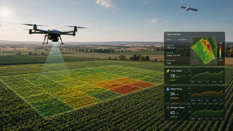 صورة توضيحية
منشأ التوريد
تركيا
نطاق المشتريات
مواصفة توريد
آخر مراجعة
13/07/2026
صياغة تحريرية وإرشادات مقارنة أُعدّت للمساعدة في تحديد المتطلبات.
نطاقات تخطيطية وليست تكوينًا نهائيًا مضمونًا.
تدعم المواد العامة السياق الفني؛ ولا تزال التفاصيل التجارية الحالية بحاجة إلى تأكيد.
Remote sensing and crop intelligence platform
المعلمات الفنية المستخدمة لتحديد المتطلب ومقارنة التكوينات المؤكدة من المورّدين.
Remote-sensing crop intelligence platform scope for satellite, drone, weather, analytics, and field-record workflows
Satellite imagery, drone imagery, AI analytics, crop-health, water-stress, nitrogen-status, weather updates, and farm records
Crop monitoring, agronomic analysis, farm-management workflows, risk monitoring, custom analytics, and weather intelligence
Imagery sources, spatial resolution, revisit cadence, supported crops, analytic methods, integrations, user roles, data rights, and service levels are defined in the project quotation
المعلمات الفنية المستخدمة لتحديد المتطلب ومقارنة التكوينات المؤكدة من المورّدين.
تفاصيل عملية تساعد الأشخاص على مقارنة الخيارات.
Crop-health monitoring across fields using satellite and drone imagery.
Water-stress and nitrogen-status mapping for irrigation and fertilization review.
Agronomist or enterprise dashboards combining maps, field records, task records, and weather context.
Crop classification or regional monitoring where field-level and area-level signals need to be separated.
Custom no-code analysis workflows for users with specific crop or risk indicators.
تتطلب هوية المورّد والمنشأ والتوفر والتكوين النهائي والشهادات والسعر ومدة التوريد والضمان والتسليم وشروط العقد تأكيدًا حاليًا.
المنهج والمصادر والسياق المستخدم في إعداد صفحة البحث هذه.
This profile defines a sourcing requirement for remote-sensing crop intelligence platform. Suitable suppliers, origin, availability, and commercial terms are confirmed for the buyer’s project. The sourcing brief is structured around capacity, application, operating environment, required standards, destination, and delivery scope; the exact configuration requires supplier confirmation.
| Layer | What it provides | Project specification |
|---|---|---|
| Imagery inputs | Satellite and drone imagery with project-defined acquisition and processing workflows. | Resolution, revisit frequency, drone service process, cloud handling, archive, and field-boundary setup. |
| Crop-health analytics | Crop-health monitoring organized by crop and growth stage. | Crop support, phenology logic, stress-detection threshold, and field-scouting validation. |
| Water and nitrogen status | Water-stress and nitrogen-status analysis for spatial crop management. | Index or model, calibration, local agronomic review, and suitability for variable-rate decisions. |
| Farm-management workflow | Recording of field operations, tasks, resources, income, and expenses. | Team permissions, exports, integrations, and audit trail. |
| Custom analysis and AI | Configurable analysis workflows for satellite, drone, weather, and field data. | Model governance, confidence reporting, input data, privacy, and human review. |
AgriTech.tr can structure the technical requirement and compare current supplier responses for the buyer’s project. Installation, commissioning, operator training, warranty, spare-parts, and after-sales scope must be confirmed in each supplier quotation. The final scope should be documented against the approved application, capacity, site conditions, destination, and delivery schedule in the selected supplier quotation and contract.
المنهج والمصادر والسياق المستخدم في إعداد صفحة البحث هذه.
Technical reference used for system specification, project engineering, and procurement planning.
Technical reference used for system specification, project engineering, and procurement planning.
Technical reference used for system specification, project engineering, and procurement planning.
توضّح المؤشرات مصدر المعلومات العامة وما لا يزال بحاجة إلى تأكيد. وهي ليست شارات اعتماد للمورّدين.
تقييم AgriTech.tr
صياغة تحريرية وإرشادات مقارنة أُعدّت للمساعدة في تحديد المتطلبات.
نطاقات هندسية نموذجية
نطاقات تخطيطية وليست تكوينًا نهائيًا مضمونًا.
3 مصادر عامة
تدعم المواد العامة السياق الفني؛ ولا تزال التفاصيل التجارية الحالية بحاجة إلى تأكيد.
ادعاءات مقدّمة من المورّد
لا يتضمن ملف الأدلة هذا أي ادعاء مقدّم من مورّد.
معلومات تم التحقق منها بالوثائق
لا يوجد سجل تحقق أساسي مرفق بهذا الإدراج.
صور الإدراج
الصور توضيحية وقد لا تُظهر التكوين النهائي الذي سيتم توريده.